


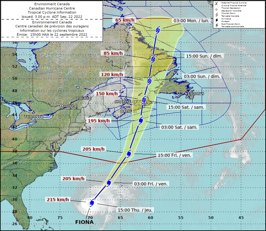
According to Environment Canada, Hurricane Fiona will continue northward and will make landfall in Nova Scotia late Friday or early Saturday.
Currently, Hurricane Fiona is just over 2,000 kilometres south-southwest of Sable Island and is being blown by winds of 213 km per hour.
Hurricane Fiona is currently moving north-northeast at a speed of 24 kilometres per hour and has reached a Category 4 hurricane status.
On Thursday, the hurricane is expected to turn northeast and then speed up as it reaches eastern Quebec and the areas along the Atlantic coast. As per Environment Canada update issued at 9 a.m. today, the storm is shaping up as a severe event for Atlantic Canada.
On Friday night, Hurricane Fiona is expected to transition into a post-tropical storm and reach Sable Island.
Then, on Saturday morning, Hurricane Fiona is anticipated to make landfall across eastern mainland Nova Scotia and Cape Breton Island. Early on Sunday, the storm will make landfall on the north shore of lower Quebec and in southeast Labrador.
There is a misconception that the eye of a hurricane is a safe place to be, but don’t be fooled. Though conditions in the eye are calm, this is short lived and is followed by a rapid increase in wind speeds with the passage of the eye. #Hurricane #Fiona pic.twitter.com/SXZwkJnwIA
— ECCC Canadian Hurricane Centre (@ECCC_CHC) September 22, 2022
Although it may be greater in locations closer to the hurricane’s path, Fiona is predicted to cause widespread rainfall of 100 to 200 millimetres.
Eastern Prince Edward Island, eastern Nova Scotia, western Newfoundland, eastern Quebec, and southeastern Labrador will be severely impacted by severe winds and rains, according to the Canadian Hurricane Centre.
Late on Friday, winds are anticipated to hit the area, which will continue through Saturday. According to Environment Canada, similar cyclones of this kind have caused structural damage to structures.
Coastal regions might also anticipate large waves. On Friday night, waves in eastern Nova Scotia might top 10 metres, and by Saturday morning, comparable waves are predicted to reach Newfoundland. Wave heights of more than 12 metres may be present in the eastern parts of the Gulf of St. Lawrence.
As the province waits for Hurricane Fiona to arrive, Nova Scotians and residents of the Atlantic Canada region are warned to prepare.
In a briefing on Thursday afternoon, Bob Robichaud, warning preparedness meteorologist with the Canadian Hurricane Centre, stated that this storm will be “very severe and hazardous for Eastern Canada.”
As you get #NSStorm ready, ensure you have enough food and water for 72 hours as well as first aid supplies, gas in your car, batteries for flashlights and radios, and that prescriptions are filled. #HurricaneFionahttps://t.co/1IDhhaFO2j pic.twitter.com/LJxHsjmb71
— Nova Scotia EMO (@nsemo) September 22, 2022
He echoed the findings of Environment Canada, stating that heavier winds would start to blow into the area late on Friday and that Saturday morning might see some “severe winds.”
Robichaud said that although though Hurricane Fiona will be a post-tropical storm by the time it makes landfall in Atlantic Canada, it won’t be any weaker since it will still possess both tropical and post-tropical features.
He also added that the hurricane’s trajectory greatly influences the storm surge’s size. The Canadian Hurricane Centre is monitoring it and will have additional information when it comes closer to having an impact.
Heavy rainfall is expected in parts of the province with #HurricaneFiona and may result in flooding.
Are your home and property prepared? https://t.co/2QtkLneZMw #NSStorm pic.twitter.com/RVpUB0ua1h
— Nova Scotia EMO (@nsemo) September 22, 2022
Nova Scotians, according to Robichaud, should be ready for extreme weather. Current projections include wind speeds that have previously caused power disruptions and structural damage during storms.
Robichaud remarked that attempting to compare hurricanes is “always a very tough thing,” adding that it depends on the storm’s severity. A “very huge storm” is what Hurricane Fiona will be, according to the prediction.
Similar to what Dorian achieved, it will “cover a pretty big region,” he declared.
“This storm will be a little bit stronger than Dorian was, and greater in magnitude than Juan was.” He advised locals to prepare for “perhaps a lengthy amount of time” without power. He emphasised that staying current with the prediction is crucial. It’s going to be a really bad storm.