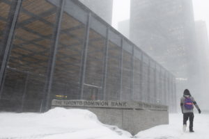
TORONTO _ Schools were closed and flight cancellations were stacking up in Toronto as a potent winter storm threatened to dump snow, ice and freezing rain on a large swath of southern Ontario.
Environment Canada says the city could see up to 25 centimetres of snow and ice starting this morning, with winds gusting to 70 kilometres an hour before the messy system turns to rain and ice pellets.
The weather agency has issued dozens of winter storm advisories for all of southern Ontario and parts of the northern portion, as well as much of southern Quebec.
Several schools and universities in the Greater Toronto Area closed their doors in advance of the storm, which was also forecast to pack strong easterly winds gusting to 80 km/h near the shores of Lake Ontario and greatly reduce visibility.
Arrival and departure boards at Toronto airports were clogged with cancellations and delays, particularly at Billy Bishop airport in the city’s downtown.
The system is associated with a Colorado low that’s expected to move out of southern Ontario on Wednesday and into New Brunswick and Nova S
cotia, which were also under weather warnings ahead of its arrival.